Taking imagery of bike lanes at risk and using it to help fix bike parking
This post originally appeared on the BikeSpace blog.
If you bike in Toronto, you probably know that the provincial government has passed legislation (Bill 212) preventing the installation of any bike lane that would remove a vehicle lane and given themselves the power to go remove existing bike lanes, including on Bloor Street, Yonge Street and University Avenue in Toronto.
Cycle Toronto successfully obtained a temporary injunction on the bike lane removals in April, but that injunction is currently being appealed by the Province, and may only last until the final decision is issued. Also in their May 15 budget, the government added Queen’s Park Crescent and Avenue Road to the priority removal list, either as an expansion of their short-term hit-list, or an admission that someone forgot that the road changes its name.
A year from now, several backbone routes in Toronto’s cycling network: Yonge, University–Queen’s Park–Avenue, and Bloor, may be gone or significantly changed. Some of the most recent improvements to Bloor and University (e.g. the protected intersection at Bloor and St. George) as well as the addition of bike lanes to Avenue Road were only completed late last summer, and have been in place for less than a year.
This leaves the possibility that the improvements from last summer will come and go without being captured in Google Street View, the digital record of “what did this street look like” that most people instinctively turn to. As of the date of writing, the last capture of University Avenue just south of College St (September 2023) does not include any of the “permanent” infrastructure that is now there, and Bloor St near U of T and Avenue Road up to Davenport (July 2024) are in construction and pre-construction, respectively.
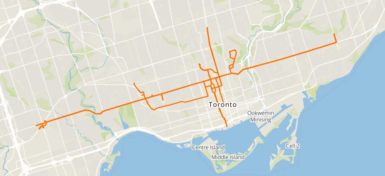
These critical cycling routes deserve to be saved, and I hope that we get more than just one year with this infrastructure that advocates worked so hard to put in place. But even in the worst case, they deserve to be remembered, so I attached a GoPro Max to my bike helmet and biked along each route to take 360° imagery of all of them this month. It’s now uploaded to two services that allow for permissive use:
- View on Mapillary: Imagery in Toronto from 2025 onwards
- View on Panoramax: Imagery in Toronto from 2025 onwards
I’m also planning to review these routes in OpenStreetMap to ensure that researchers have access to data that accurately reflects the infrastructure on the ground as of this spring. (If that’s something you want to help out with, feel free to email us and let me know!)
Why not upload the imagery to Google Street View? After all, volunteer contributors can upload imagery to the service, and it’s where most people would look first. Unfortunately, both legally and technically, Street View is not really designed to be useful to anyone other than Google. As one notable example, Google Street View cannot be used by contributors to OpenStreetMap, which is a common data source for transportation research (such as this analysis of the cycling network in Victoria, BC).
Using street-level imagery to fix bike parking
For dense urban streets, such as Bloor St, street-level imagery can help with BikeSpace’s goal of improving and better understanding bike parking in Toronto. In person surveying can take a significant amount of time, but with a helmet-mounted camera, you can record the condition of sidewalk bike parking very efficiently and then easily review and report it from home. Having a photographic record of the street also opens up opportunities to analyze the maintenance condition of bike rings over a large area at one point in time, or to efficiently estimate bike parking usage in an area.
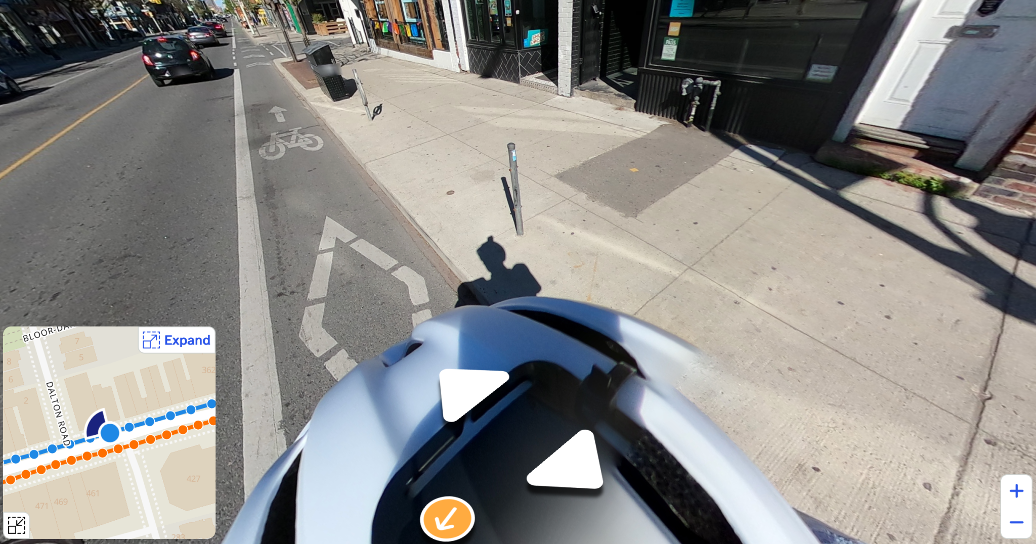
A broken bike ring on Bloor St visible on imagery uploaded to Panoramax
Good imagery also helps with getting things fixed — in order to dispatch a contractor to fix a bike ring, for example, the City has to be able to document the exact location of the bike ring and needs to be able to give precise instructions about what work is required. High quality imagery has the potential to make this much easier, and may eliminate the need for City staff to conduct site surveys in some cases.
Applying technology to street maintenance is something that the City Transportation Department is exploring, with a February report on bike lane inspection plans noting that “Transportation Services is considering motor vehicle mounted technology to collect data on pavement conditions, broken assets and other deficiencies.” They add that this “would automatically generate new work orders for maintenance crews to efficiently organize their tasks of repairing potholes and road discontinuities, replacing pre-cast curbs and bollards, as well as conducting concrete repairs.”
For street furniture and bike lane maintenance, taking imagery from a bicycle instead of a vehicle would be even more effective, since it significantly cuts down the number of situations where parked or moving cars are in the way, and gives a much clearer and closer image of the relevant infrastructure and paving condition. Something for the City to consider!
Beyond Bloor, University, and Yonge
Street-level imagery has a number of potential uses, ranging from personal navigation to research into topics such as infrastructure, health, transportation, accessibility, and real estate valuation. (For a good overview, see this 2021 review paper by Filip Biljecki and Koichi Ito from the National University of Singapore).
I plan to continue recording imagery of bike routes in Toronto — with these main routes, I’ve probably covered at least one-third of Toronto’s ~100km of protected bike lanes, and could probably get through all of them this summer, as well as a decent proportion of the painted bike lane routes. It would also be fun to capture imagery in some of the areas where Google Street View has outdated or missing coverage, such as some of the park and nature trails in Scarborough.
If you think of some routes that could really use good imagery, or ideas for how to use open-license street-level imagery to make Toronto better, feel free to get in touch!