Street-level imagery: licensing challenges and benefits of recording from a bike instead of a vehicle
This post originally appeared on the BikeSpace blog.
In the previous post, I talked about collecting street-level imagery while biking using a helmet-mounted camera and sharing it via services that are open license.
In this post, I’ll dig deeper on two related questions. First, why is it important to use open license services instead of Google Street View? Second, what are the advantages of collecting imagery from a bike instead of the “traditional” car-mounted method?
Technical and legal limitations of using Google Street View for research
A 2021 review paper by Filip Biljecki and Koichi Ito from the National University of Singapore found that Google Street View was the dominant service used in research projects, being used in about two-thirds of studies globally 1. The next most-used services were Baidu and Tencent, so outside of China, the proportion of studies using Google Street View is even higher.
Despite its popularity, use of Google Street View for academic research often conflicts with the terms of use for the service, which prohibit “Creating data from Street View images”, “Using applications to analyze and extract information”, and “Downloading Street View images”, even for academic and nonprofit projects 2.
“Fair Dealing” or “Fair Use” provisions in copyright law may allow researchers to use Google Street View imagery regardless, though a 2024 paper by researchers at Utrecht University in The Netherlands notes that “invoking fair usage over Google’s term of service [under U.S. law] is an area of active litigation and is currently unsettled” and that “even with the exemptions granted under [European copyright directives to enable access for researchers], it remains questionable whether proprietary street view images from Google are available for research purposes” 3. In most jurisdictions, Fair Dealing–type defenses are not definitive until proven in court, and the Utrecht University researchers note that in Europe the “possibility of legal action has a chilling effect on the accessibility and reusability of the data”.
In addition to legal uncertainty, there are technical limitations on the quality of Google Street View data that researchers can access. Biljecki and Ito note in their review paper that unlike the web interface, the Google Street View API does not allow users to obtain past images, only the most current image taken at a location. The resolution of images that can be obtained via the API is also limited (developer documentation notes that the maximum image resolution returned by the API is 640 × 640 pixels) 4.
Open license services such as Panoramax or Mapillary allow researchers to use imagery without any copyright concerns and generally allow for full-resolution images to be accessed via an API. However, since open license services generally rely on user-contributed imagery, the quality is much more variable, and road network coverage is less comprehensive. In theory, Google Street View also has greater “temporal resolution”, i.e. more images of the same location at different points in time, though in practice, this benefit is not easily accessible to researchers, as noted above.
Limitations of using vehicle-collected imagery for cycling and pedestrian analysis
Although commercial street-level imagery services sometimes collect imagery using e.g. backpack-mounted equipment, images are predominantly collected by vehicle-mounted systems. This means that pedestrian or cycling infrastructure is more likely to be obstructed (e.g. by other passing or parked vehicles), and that imagery is often not collected for pedestrian or cycling routes where vehicle access is not logistically or legally feasible (e.g. on park trails and “cut-through” paths between roads).
For cycling infrastructure, a common design is to place car parking in-between the driving lane(s) and bike lane (see for example, the Bloor bike lane just west of Clinton St). This has a number of benefits, including reducing the risk of vehicle–bicycle collisions and “dooring”, reducing speeding by influencing drivers’ perceptions of space, as well as providing additional separation, distance, and protection that makes it much more pleasant and safe for pedestrians and cyclists to use the street. However, even with the high vantage point used by vehicle-mounted systems, in these situations, the pedestrian and cycling infrastructure is much less visible (see, for example, the equivalent area in Google Street View). By recording imagery from the bike lane, objects such as bike parking, street furniture, and even store signage are less frequently occluded, and the paving condition of the sidewalk and bike lane can more easily be determined.
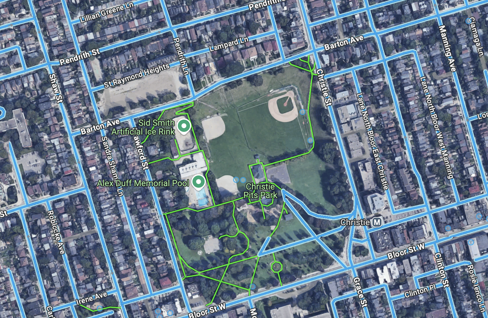
Google Street View coverage of Christie Pits park
In Toronto, Street View imagery of cycling and pedestrian routes that do not allow vehicle access almost always relies on user-submitted imagery instead of imagery collected by Google. Many major trails have been captured in remarkable quality by users of the AccessNow App or by a small number of individual contributors. However, trails in more suburban neighbourhoods (e.g. near the Toronto Zoo in northeast Scarborough) and within parks are often not mapped. Small connecting pathways often found in suburban neighbourhoods usually do not have imagery as well. Where there is Google-collected imagery (e.g. Sunnybrook Park, trail next to Don Valley Brickworks, Glen Cedar Pedestrian Bridge), it is often more than 5-10 years out of date. Since these routes play an important role in cycling and pedestrian trips, this limits the potential for street-level imagery to be used in cycling and pedestrian research.
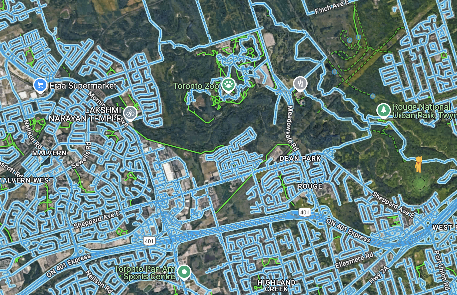
Google Street View coverage in North-East Scarborough: no imagery available for the final segment of the Meadoway and the Upper Rouge Trail
It’s hard to imagine open license services having competitive coverage of the road network compared to Google Street View, even with a very strong community of local contributors. However, for cycling and pedestrian routes, a small group of contributors could easily build an open license imagery dataset that is comparable or better to what Google Street View offers. Bicycle-collected imagery can have fewer occluded features than Google’s vehicle-collected images, open services can offer researchers higher resolution imagery and problem-free licensing, and since Google’s coverage of cycling and pedestrian–only routes also primarily relies on user contributions, it is easier for contributors to offer competitive image quality and coverage for everywhere a car cannot go.
-
Biljecki, F., & Ito, K. (2021). Street view imagery in urban analytics and GIS: A review. Landscape and Urban Planning, 215, 104217. https://doi.org/10.1016/j.landurbplan.2021.104217 ↩
-
https://about.google/brand-resource-center/products-and-services/geo-guidelines/#street-view ↩
-
Helbich, M., Danish, M., Labib, S. M., & Ricker, B. (2024). To use or not to use proprietary street view images in (health and place) research? That is the question. Health & Place, 87, 103244. https://doi.org/10.1016/j.healthplace.2024.103244 ↩
-
https://developers.google.com/maps/documentation/streetview/usage-and-billing ↩